


Lead weather presenter
BBC News
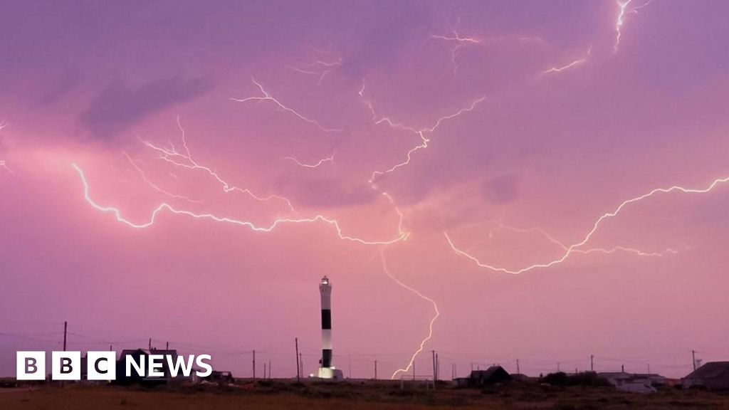
 BBC Weather Watchers / KentGardener
Yellow weather warnings for rain and thunderstorms remain for much of the UK after storms hit parts of England overnight following the hottest day of the year so far.
An amber weather warning was in place for the east and south-east England overnight and thunderstorms brought extremely heavy rainfall to parts of Kent, with the Dover area experiencing flooding.
While the amber warning has now ended, a yellow warning remains in place for Wales, western and northern England, Scotland and parts of Northern Ireland on Saturday.
The Met Office said the weather will gradually move northwards during the day though a risk of isolated smaller scale thunderstorms forming remains.

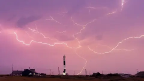
 BBC Weather Watchers/ Peter and Leah
Rain and lightning rolled in on Friday night after temperatures exceeded the previous recorded high of 29.3C in Kew, London, on 1 May.
According to Met Office provisional figures, the new highest temperature of the year so far was recorded in Santon Downham, West Suffolk with 29.4C.
Scotland also had its warmest day of the year so far with 25.7C recorded at Lossiemouth in Moray.
A spokesperson for the Met Office said that temperatures in the south east were “comfortably 9C or 10C higher than the average expected for this time of year”.
An amber warning for thunderstorms was then issued for an area in the east and south-east from Eastbourne, Sussex, in the south up to Cromer in north Norfolk from 20:00 BST on Friday till 05:00 on Saturday.
Late on Friday night, Heathrow Airport apologised to passengers for flights delayed by “adverse weather conditions”.
More than 30,000 lightning strikes were recorded overnight up to 06:00 on Saturday.
Although the Met Office said the “vast majority” had been over the sea, East Sussex Fire and Rescue Service said a lightning strike was deemed the likeliest cause of a fire in a residential building in St Leonards-on-Sea.
There were no reports of casualties and the fire has been extinguished.
It was not just the south-east that saw heavy rainfall on Friday, however.
In Devon, North Wyke near Okehampton saw 36.4mm of rain.
Five flood warnings were issued overnight by the Environment Agency, all in the South West, alongside 49 flood alerts in the South West, South East and Midlands.
A further six flood alerts have since been put in place by Natural Resources Wales in South Wales.
National Rail also said a landslip had stopped all services between Exeter St Davids and Okehampton, with the weather conditions meaning it is not safe for engineers to reach the site.
Disruption is expected until 13:00 with rail operators warning customers to check for updates on services on Saturday morning.
Yellow weather warnings remain in force more generally across the South West, North East and North of England, Wales and much of Scotland where the thunderstorms could be just as severe but more localised.
The Met Office warns that some areas could see 30-50mm of rain in a few hours, while a few locations could reach up to 80mm.
A further yellow warning is also in force in the eastern half of Northern Ireland from 06:00 to 18:00 BST on Saturday.
The rain will spread north and west, turning more showery in the afternoon but there will still be a risk of thunderstorms, the weather agency said.
The heat and humidity has been building gradually, especially across northern and eastern parts of England.
With the rising humidity and heat, thunderstorms will bring the end to the hot spell.
Temperatures will be lower on Saturday with highs like low to mid-twenties across eastern England and high teens elsewhere.
 BBC Weather Watchers/ Bettys Hot Spot